-40%
90 Sacramento Calif gold mines RARE 1st ed report, separate maps, locations VG
$ 45.81
- Description
- Size Guide
Description
Rare old 1st-edition report has all goldmines in Sacramento County, California
More than 90 gold mines; pinpoints some with exact
coordinates; also has mining history, mine output!
2nd one of these I've ever listed; buy it before it's gone
All gold mines
— 12, 12C, 12D, 12B, 12D are gold dredges, just south of the Southern Pacific Railroad heading east from Sacramento Calif. Mine numbers are keyed to the text for more information — like owners, production totals and important mining details.
T
his very rare first-edition report lists over 90 Sacramento County gold mines!
This is the second one of these in 15 years that we have listed on ebay. Yes, it is that difficult to find! So buy it now, or forever hold your peace!
Crossed pickaxes and numbers locate active 1955 lode-gold mines. Number 7 is the Dorian, active in 1894, including a FOUR FOOT WIDE gold vein in slate.
This 57-year-old report describes
every known gold mine
— over 90 of them — in 1955 Sacramento County, California. And it pinpoints some mines on the included separate detached oversize map, and locates others by coordinates in the text. You will NOT find a better copy ever at any price.
Open to prospecting!
Some of these mines are on public lands and are open to prospecting and exploration. If the mine is on public lands, you do NOT need permission to metal detect, pan for gold or pull samples for gold content.
This report is not some cheesy tourist piece of junk available in every Sacramento gift shop. This is a hard-to-find first edition. It is an official report originally put out and put together by the State of California. What's more: It's in super condition. Just some minor cover stains (see condition details later in ad) and interior yellowing. The maps may be copies (can't tell) but they're in perfect shape and look as good as the originals.
Still a shipload of gold left
By the time of this report, Sacramento had produced over 8 million bucks of gold. And remember, that's at 1955 prices. At today's prices, that's about .7 BILLION of gold ... Yup, that's "billion" with a "b."
In 1955, Sacramento was second in county gold production for ALL California. Since World War Two, Sacramento County represented an astonishing 23-28% of gold production for ALL of gold-rich California. And with those top stats, you can bet Sacramento County still has a shipload of undiscovered gold to offer. Hardly a year goes past without some lucky so-and-so hitting the big time with a monster Sacramento nugget or super-rich placer gold.
So what are you waiting for? Buy this book for a few measly bucks and go out and make millions!
Last CDMG report on Sacramento
And this is the newest, most-detailed report on Sacramento County gold mining published by the state division of mines in the JoMG series, which stopped publication about 1958. This book is considered primary source material; much of this info is available
nowhere else
. And the book itself is in very good condition, one of the best copies that I have seen of this rare fragile title. So buy it now or forever hold your peace. Once it's gone, it's gone.
Big-deal mines, not dinky deposits
We're not talking descriptions of a few dinky little prospect pits here. Many of these mines were killer gold sources, making a few owners very VERY rich. Sure, there were gold-stock scams California, but Sacramento County produced REAL gold from REAL mines.
Gold mines described
Here are just a few of the gold mines described in the text:
Evanis mine
(Broder Ranch), lode gold (lode gold!), three miles east of Folsom — Idle since the '30s. In 1955 owners erected a new headframe hoist and a 25-ton stamp mill but ran out of money in 1953. Three shafts on the property, one caved. Still abandoned (as of '55) and waiting for a miner to strike it rich with ore that is now worth 40 times more than it was in 1955.
Capitol Dredging Company
, 4.5 miles west of White Rock — Subsidiary of Yuba Consolidated Gold Fields, which continuously operated dredges in Sacramento County since 1927! Shut down in 1950-'52, again because of rising costs, not of gold but rising production costs. This isn't a concern any more. Gold was around 30 bucks in the early '50s. It's now worth much much more. Capitol dredges processed about 10 million cubic yards of rich gold ore in 1931-'35!!!
Consummnes Gold Dredging Company,
field office at site of old Sebastopol
—
Produced 3.4 million cubic yards of rich gravel in 1938 alone, yielding 10,018 ounces of gold. That's about million at today's gold prices. Went idle in 1951, once again because of low gold prices. Well, they aren't low any more!!!
General Dredging Company
, office near Natoma — Another huge operation shuttered because of low '50s gold prices. This sucker processed over 200 cubic yards of ore an hour and employed 20 men at their Alder Creek operation, 2.5 miles south of Folsom. This was no little mom-and-pop op. Yes, range-and-township coordinates are given for the dredge location.
Rebel Hill
(drift mine), 1890s — No one really knows how many millions of bucks drift mines produced because many workers were Chinese, who sold directly to other Chinese and didn't go through official channels, where totals were kept. Rebel Hill in the 1890s employed 40 men at least. At least six drift mines were kicking butt in the Folsom area in 1894 alone.
And other mines
, large and small, active and abandoned, famous and forgotten. (Be aware that unlike other similar CDMG county reports, this one does seem to have less exact mine locations.)
Natomas Company's No. 6 bucket-line dredge digging 75 feet below the water level, processing an astonishing 4 million cubic yards of rich gravels annually.
Lists mines and
prospects in two ways
One of the real values of this report is that it lists mines in two ways:
First, it alphabetically summarizes a few of the more important or interesting gold mines and prospects in the text. These descriptions can run from a few lines to several paragraphs, depending on the importance of the mine.
Second, it also alphabetically lists in a table
every known
gold mine and prospect in the county. Entries in this sizable 11-page table can include the owner's name/address, and the exact location — either in
infallible range-and-township coordinates
or a number keyed ton the map! Just plug them into your GPS or look them up on the appropriate topo, and you're there. Some mines listed don't have exact locations, but not to worry. Some of these mines are listed on various topos of the area (not included). There are several web sites on the internet that have ways to convert range-and-township coordinates into GPS coordinates.
Treasure trove of information
How can you look for "color" in Sacramento County mine dumps if you don't know
where the best dumps are? Why waste weekends randomly digging through tailing piles for specimens or panning in areas that have absolutely no record of gold production?
We have many MANY more rare mining books! Just visit our ebay store, Rare Mining Books:
http://stores.ebay.com/Rare-Mining-Books?_rdc=1
This report can be a real aid in leading to likely pay-dirt areas. It's also a treasure trove of information for history buffs, bottle collectors, photographers, geologists, hikers, offroaders, rockhounds, prospectors, treasure hunters, metal detector enthusiasts — just about anyone interested in learning about, exploring or prospecting old mine sites in historic Sacramento County. one of the earliest areas settled in California way before it was California.
I said it before, and I'll say it again: This is not some gift-shop rockhound book; it was prepared by the California Division of Mines — written about miners for miners by miners.
When I say that this report is rare, I don't use that term lightly. This is the first one of these that I have seen in 26 years of looking for California mining items.
Also a valuable tool for stock certificate collectors
Because this report lists mine owners and different names for the same mine, it is also a valuable tool for collectors of stock certificates. Some mine descriptions contain brief histories of the mines in question (including dates of actual production) and previous owners.
Of course, this book also covers other mineral deposits in Sacramento County — from gravel to silver to gas and oil.
Where is it?
Sacramento County is in northern California. It's bounded on the north by Yolo, Sutter, Placer and El Dorado counties. To the south are Contra Costa, San Joaquin and Amador. Other adjoining and nearby counties include Solano, Colusa, Yuba, Nevada, Calaveras, Stanislaus and Alameda.
The Book:
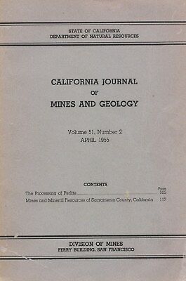
California Journal of Mining and Geology,
1955, State of California Department of Natural Resources, Division of Mines, San Francisco, six by nine inches, about 100 pages total, about 70 are about Sacramento County mineral resources, by Denton W. Carlson. First and only official edition, no official reprints ever issued, paper covers, stapled binding.
Near-perfect condition; just some sun fading on the covers, sticker and stamp on cover, barely even worth mentioning. You will not find a better copy anywhere at any price. Inside condition is near-fine. Looks like it might never have been opened before we cracked it for the first time. Corners are BARELY bumped.
Contains BOTH oversize maps in rear pocket in near-perfect folded shape. The maps may be copies (can't tell) but they're in perfect shape and look as good as the originals. One shows all the mines in the county, keyed to various entries in the text.
Be aware that various cheesy Indian and Chinese reprints now appearing on the market have +NO+ separate maps. Without those maps, those illegal reprints are completely useless. Besides, the printing quality on the reprints is just horrible. If they were any good, we'd sell them.
Payment methods
and domestic shipping
Paypal only. FREE shipping and handling via FAST priority mail, noy slower than molasses-in-winter parcel post or media mail (even slower). You should have this report in days, no weeks, unlike many other ebay sellers.
I pride myself on bulletproof packaging and ship in sturdy cardboard boxes or hugely reinforced envelopes. We have never ever had one item damaged in shipping ever in 15+ years of ebay selling.
Sorry, absolutely no pickups. No international shipping.
The fine print:
Contact me if you have any questions about the item or terms of sale.
I post feedback once a week. Not responsible for typographical errors.
Good luck and thanks for looking!
Hard Materials Company's suction dredge on the American River. Barge derrick (on right side) enables operator to raise or lower suction nozzle.
Communities and nearby sites
Communities and sites in or near Sacramento County include:
Citrus Heights, Elk Grove, Folsom, Galt, Isleton, Rancho Cordova, Sacramento; Adams and Company Building, African Methodist Episcopal Church, B.F. Hastings Bank Building, Booth Company, California Almond Growers exchange process facility, California’s First Passenger Railroad, California State Capitol, Camp Union, Chevra Kaddisha Cemetery, China Slough, Folsom Lake State Recreation Area, Sutter's Fort, D.O. Mills Bank Building, E.B. Crocker Art Gallery, Eagle Theatre, Ebner's Hotel, Elk Grove Free Library, Fifteen Mile House, First Jewish Synagogue owned by a congregation on the west coast, California State University, Folsom Terminal, Folsom Powerhouse, Governor's Mansion, Grave of Alexander Hamilton Willard, Grave of Elitha Cumi Donner Wilder, Lady Adams Building, Michigan Bar, Murphy's Corral, Original Sacramento Bee building, Orleans Hotel, Pioneer Mutual Volunteer Firehouse, Pioneer Telegraph Station, Sheldon Grist Mill, Soughhouse, Sam Brannan House, State Indian Museum, Sutter's Landing, First Transcontinental Railroad, Haggin Oaks Municipal Golf Course, Western Hotel, and of course the one-and-only What Cheer House.
